
post by Torran Semple (2021 cohort)
Through the Horizon Impact Grant, I collaborated with Broxtowe Borough Council to support ongoing work on the identification and understanding of damp and mould cases in housing stock.
Building on previous work with the Council on fuel poverty and retrofit schemes, the project applied data science and spatial analysis techniques to explore the distribution of damp and mould across Broxtowe. The aim was to support more targeted decision-making around housing inspections and remedial interventions.
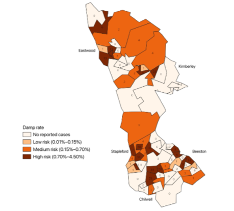
Figure 1 illustrates the output of the univariate spatial analysis. In practice, this map can be used to target Lower Layer Super Output Areas (LSOAs)—geographical units of ~600–800 households—with the most severe issues. I also began developing bivariate maps to assess the correlation between fuel poverty and damp and mould, given the strong link between these conditions. To achieve this, I developed an area-level dataset combining damp and mould, fuel poverty, and Index of Multiple Deprivation (IMD) statistics. This dataset is, in itself, a useful resource for BBC, as they had not previously examined the spatial relationship between these variables.
The work highlights how spatial data science can be used to support local authorities in understanding complex, overlapping challenges in housing quality, energy vulnerability, and public health.